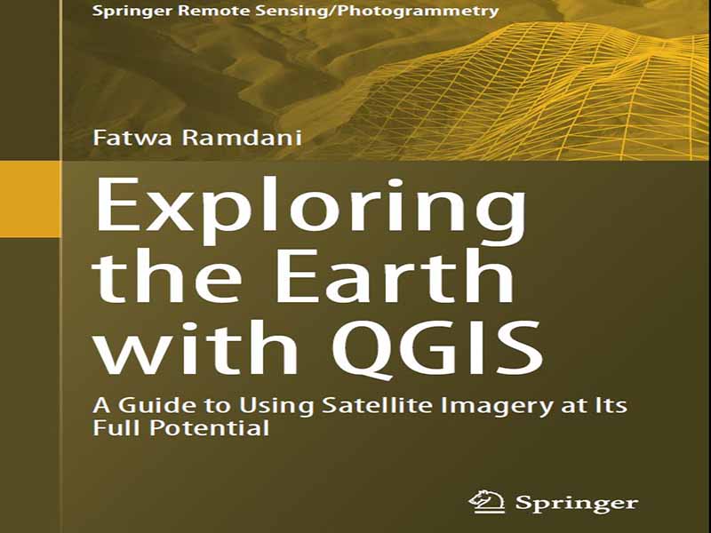
- عنوان کتاب: Exploring the Earth with QGIS -A Guide to Using Satellite Imagery at Its Full Potential
- نویسنده: Fatwa Ramdani
- حوزه: ماهواره
- سال انتشار: 2023
- تعداد صفحه: 243
- زبان اصلی: انگلیسی
- نوع فایل: pdf
- حجم فایل: 8.84 مگابایت
در سالهای اخیر، حوزه سنجش از دور زمین با توسعه فناوریهای جدید ماهوارهای و در دسترس بودن حجم عظیمی از تصاویر با وضوح بالا، به طور چشمگیری گسترش یافته است. در نتیجه، تقاضای فزایندهای برای متخصصان GIS که در استفاده از تکنیکهای سنجش از دور برای تجزیه و تحلیل و تفسیر این مجموعه دادهها مهارت دارند، وجود دارد. با پیشرفتهای سریع در فناوری ماهواره، سنجش از دور زمین به ابزاری ضروری برای طیف وسیعی از کاربردها، از نظارت بر محیط زیست گرفته تا مدیریت بلایا، تبدیل شده است. با این حال، حجم عظیم دادههای تولید شده توسط این ماهوارهها میتواند برای بسیاری از محققان و متخصصانی که فاقد مهارتها و ابزارهای لازم برای پردازش و تجزیه و تحلیل آنها هستند، طاقتفرسا باشد. اینجاست که QGIS وارد عمل میشود. QGIS یک نرمافزار قدرتمند و متنباز سیستم اطلاعات جغرافیایی (GIS) است که به طور گسترده در زمینه سنجش از دور زمین مورد استفاده قرار گرفته است. این نرمافزار یک پلتفرم کاربرپسند برای پردازش، تجزیه و تحلیل و تجسم تصاویر ماهوارهای فراهم میکند و کاربران را قادر میسازد تا از پتانسیل کامل دادههای سنجش از دور زمین استفاده کنند. QGIS یک نرمافزار GIS متنباز است که به دلیل رابط کاربری بصری و ابزارهای قدرتمند تجزیه و تحلیل، به سرعت برای کاربردهای سنجش از دور زمین محبوب شده است. در این کتاب، من کل فرآیند را از جمعآوری و پیشپردازش دادهها تا انجام تجزیه و تحلیل پیشرفته و تفسیر نتایج پوشش دادهام و یک راهنمای جامع برای استفاده از QGIS برای آزادسازی پتانسیل تصاویر ماهوارهای ارائه دادهام. این کتاب به 10 فصل اصلی تقسیم شده است:
1. مقدمهای بر QGIS
2. QGIS برای سنجش از دور
3. جمعآوری دادهها
4. پیشپردازش دادهها
5. مدیریت دادهها
6. مصورسازی دادهها
7. تجزیه و تحلیل دادهها
8. ادغام دادههای سنجش از دور با سایر مجموعه دادههای مکانی
9. ادغام QGIS با موتور Google Earth (GEE)
10. مطالعات موردی و نمونههایی از کاربردهای سنجش از دور زمین با استفاده از QGIS
In recent years, the field of earth remote sensing has exploded with the development of new satellite technologies and the availability of vast amounts of high-resolution imagery. As a result, there is a growing demand for GIS professionals who are skilled in the use of remote sensing techniques to analyze and interpret these data sets. With the rapid advancements in satellite technology, earth remote sensing has become an indispensable tool for a wide range of applications, from environmental monitoring to disaster management. However, the vast amount of data generated by these satellites can be overwhelming for many researchers and practitioners who lack the necessary skills and tools to process and analyze them. This is where QGIS comes in. QGIS is a powerful, open-source Geographic Information System (GIS) software that has been extensively used in the field of earth remote sensing. It provides a user-friendly platform for processing, analyzing, and visualizing satellite imagery, enabling users to unlock the full potential of earth remote sensing data. QGIS is an open-source GIS software that has quickly become popular for earth remote sensing applications due to its intuitive interface and powerful analysis tools. In this book, I have covered the entire process from acquiring and preprocessing data to conducting advanced analysis, interpretation of the results, and provided a comprehensive guide to using QGIS for unlocking the potential of satellite imageries. The book is divided into 10 main chapters:
1. Introduction to QGIS
2. QGIS for Remote Sensing
3. Data Acquiring
4. Data Preprocessing
5. Data Management
6. Data Visualization
7. Data Analysis
8. Integration of Remote Sensing Data with Other Spatial Datasets
9. Integration of QGIS with Google Earth Engine (GEE)
10. Case Studies and Examples of Earth Remote Sensing Applications Using QGIS
این کتاب را میتوانید از لینک زیر بصورت رایگان دانلود کنید:
Download: Exploring the Earth with QGIS


نظرات کاربران